Driving Distance vs Straight-Line Distance
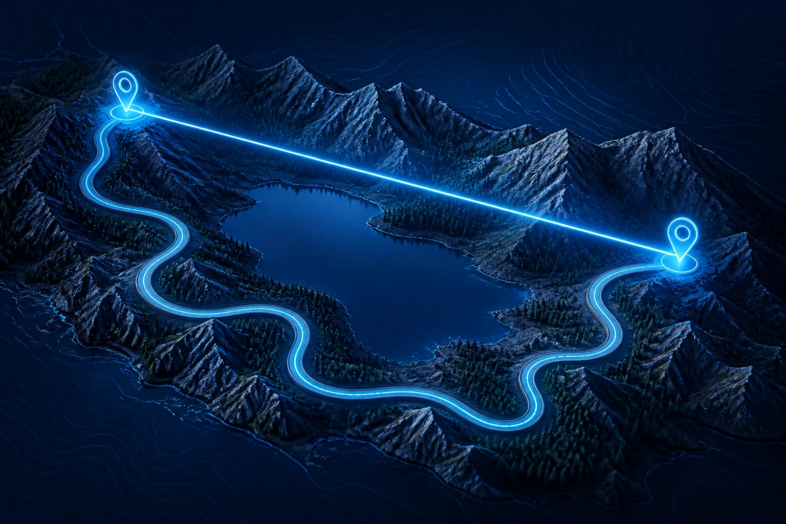
Driving distance follows the road network, while straight-line distance measures the direct geographic separation between two points. The two values can differ because roads must follow real terrain, bridges, streets, highway connections, and legal routes instead of the shortest possible geographic path.
Try it: Driving Distance Calculator
Compare the road distance between two places with the straight-line figure from our coordinate calculator.
Use the Driving Distance Calculator when you want road mileage and estimated drive time. Use the Distance Calculator when you want direct great-circle distance between two geographic coordinates.
What Is the Difference Between Driving Distance and Straight-Line Distance?
The difference is the path being measured.
Straight-line distance measures the direct geographic separation between two locations.
Driving distance measures the length of a road route connecting those locations.
For example, two places may be only 10 miles apart geographically, but the available road route could be 14 miles if a river, restricted area, road layout, or limited bridge crossing forces a detour.
The endpoints can remain exactly the same while the measured distance changes because the path is different.
What Is Straight-Line Distance?
Straight-line geographic distance is the shortest surface distance between two locations without following roads.
For latitude and longitude coordinates, this is commonly calculated as a great-circle distance.
On CalculatingDistance.com, the Distance Calculator uses the Haversine formula with a spherical Earth model to calculate this direct geographic separation.
Straight-line distance may also be described as:
- direct distance;
- air distance;
- as-the-crow-flies distance;
- great-circle distance in a geographic context.
For the concept in more detail, see As the Crow Flies Distance.
What Is Driving Distance?
Driving distance is the length of the road route between an origin and a destination.
It follows available roads rather than a mathematically direct path.
A driving route can include:
- highways;
- local streets;
- bridges;
- tunnels;
- ramps;
- interchanges;
- permitted turns;
- border crossings;
- other road-network connections.
Your Driving Distance Calculator geocodes the two locations and then calculates a route through road-network data.
Why Is Driving Distance Longer Than Straight-Line Distance?
Driving distance is usually longer because a road route is constrained by the real world.
The direct geographic path does not need to care about roads or physical access. A vehicle does.
Several factors can increase road distance.
Roads Do Not Run in Perfectly Straight Lines
Roads are built to connect communities, follow terrain, meet engineering constraints, and avoid obstacles.
A highway may curve gradually for many miles even when the destination lies in a more direct direction.
Every curve can add length compared with direct geographic separation.
Rivers and Lakes Can Force Detours
A straight line can cross water anywhere.
A vehicle can cross only where a suitable road connection exists, such as:
- a bridge;
- a tunnel;
- a ferry route supported by the routing system;
- a road around the water.
Two points on opposite banks may therefore be geographically close but much farther apart by road.
Mountains Change Road Geometry
Mountain roads often follow:
- valleys;
- passes;
- gradual slopes;
- switchbacks;
- tunnels.
The shortest geographic line may cross terrain that a road cannot reasonably or legally follow.
As a result, mountainous regions can produce large differences between direct and driving distance.
Coastlines Create Indirect Routes
Two locations can appear close across a bay, inlet, or irregular coastline.
A straight-line calculation can cross the water directly.
A road may need to follow the coastline or reach a distant bridge.
This can make road mileage substantially longer.
Road Networks Have Limited Connections
A direct line can connect any two coordinate points mathematically.
A road route can only use connected road segments.
If two nearby areas are separated by:
- a freeway with limited crossings;
- a railway corridor;
- private property;
- restricted land;
- a river;
- another barrier;
the vehicle may need to travel away from the destination before approaching it again.
One-Way Streets Can Change the Route
Urban road networks can have directional restrictions.
A road route from A to B may differ from the route from B to A because of:
- one-way streets;
- prohibited turns;
- divided highways;
- entrance ramps;
- exit ramps.
Straight-line distance does not have this directional road-network issue.
Is Driving Distance Always Longer Than Straight-Line Distance?
For the same endpoints and an ordinary road route, driving distance cannot provide a physically shorter surface path than the shortest geographic surface distance.
The straight-line or great-circle measurement provides the geographic lower-bound path between the endpoints on the chosen Earth model.
However, comparing numbers from two different tools still requires care.
A reported straight-line distance and a reported driving distance may use:
- slightly different endpoint coordinates;
- different city-center references;
- different geocoding results;
- different geographic models;
- different units or rounding.
So the comparison is most meaningful when both measurements use the same origin and destination points.
Is There a Fixed Formula to Convert Straight-Line Distance to Driving Distance?
No universal conversion factor works reliably for all locations.
You may see rules of thumb such as multiplying direct distance by 1.2, 1.3, or another factor, but the real relationship depends on the road network and geography.
For example, the ratio can be relatively small in a dense, well-connected grid and much larger where:
- mountains limit crossings;
- water separates locations;
- road connections are sparse;
- borders restrict travel;
- islands are involved.
A routing engine is therefore more appropriate than a fixed multiplier when actual road mileage matters.
What Is the Route-to-Direct Distance Ratio?
A useful descriptive quantity is:
Route Ratio = Driving Distance ÷ Straight-Line Distance
For example:
Driving Distance = 130 miles
Straight-Line Distance = 100 miles
Then:
Route Ratio = 130 ÷ 100 = 1.30
This means the road route is:
30% longer than the direct distance
because:
Percentage Difference = [(130 − 100) ÷ 100] × 100
Percentage Difference = 30%
The ratio is descriptive for that particular route. It should not be assumed to apply to another city pair.
Example: A Simple Road Detour
Suppose two locations are:
20 miles apart directly
but the road between them must curve around a lake.
The road route is:
28 miles
Difference:
28 − 20 = 8 miles
Percentage increase over direct distance:
(8 ÷ 20) × 100 = 40%
So the driving route is:
40% longer
for that specific example.
This does not mean driving distance is always 40% longer.
Driving Distance vs Air Distance
In everyday usage, air distance often means direct geographic distance rather than an actual flown route.
So:
road distance vs air distance
usually compares:
road-network distance
with:
great-circle geographic distance
A real aircraft route can also differ from the great-circle path because flights may follow airways, weather avoidance, air traffic restrictions, and operational procedures.
The direct air-distance number should therefore be treated as a geographic reference rather than a guarantee of actual flight mileage.
Driving Distance vs As-the-Crow-Flies Distance
“As the crow flies” is another everyday term for direct geographic separation.
For example:
As-the-crow-flies distance: direct geographic path
Driving distance: road route
Our As the Crow Flies Distance guide explains the direct-distance concept and the great-circle geometry behind it.
Driving Distance vs Euclidean Distance
Euclidean distance is the straight-line distance between points in a flat Cartesian coordinate system.
For:
A = (x₁, y₁)
B = (x₂, y₂)
the formula is:
Distance = √[(x₂ − x₁)² + (y₂ − y₁)²]
Geographic straight-line distance between latitude and longitude points uses different geometry because Earth is curved.
Road distance is different again because it follows a transportation network.
These three concepts should not be treated as interchangeable:
Euclidean distance
→ flat coordinate geometry
Great-circle distance
→ geographic surface separation
Driving distance
→ road-network route
For the mathematical distinction, see the Distance Formula hub.
How Is Straight-Line Geographic Distance Calculated?
For two latitude and longitude points, CalculatingDistance.com uses the Haversine formula.
In simplified form:
a = sin²(Δφ ÷ 2) + cos(φ₁) × cos(φ₂) × sin²(Δλ ÷ 2)
c = 2 × atan2(√a, √(1 − a))
Distance = R × c
where:
- φ represents latitude;
- λ represents longitude;
- R is the assumed Earth radius.
The straight-line distance calculator uses:
R = 6,371 km
For the complete derivation, see Haversine Formula.
How Is Driving Distance Calculated?
Driving distance requires a road network rather than only a geometric formula.
The general process is:
- Identify the start and destination.
- Convert those places into geographic coordinates if necessary.
- Locate the coordinates within a road-network graph.
- Find a suitable route through connected road segments.
- Sum the lengths of those route segments.
- Return the total road distance.
The driving calculator on this site uses location geocoding followed by an OSRM driving-route request.
See How Driving Distance Is Calculated for the detailed routing methodology.
Why Can Google Maps and Another Driving Calculator Give Different Distances?
Different routing systems can select different routes.
Potential reasons include:
- different map datasets;
- different update times;
- different routing algorithms;
- different road restrictions;
- different route preferences;
- different geocoding results;
- different treatment of tolls or road classes.
One tool may prefer the shortest route.
Another may favor a route expected to take less time.
Therefore, road distance is linked to the selected route, not merely the endpoints.
Why Can Straight-Line Calculators Give Slightly Different Results?
Even direct-distance tools can differ slightly.
Possible causes include:
Different Coordinates
A city can be represented by different reference points.
Different Earth Models
One calculator may use a spherical Earth model while another uses an ellipsoid.
Different Earth Radius Values
Spherical calculations can use slightly different representative radii.
Different Precision
One calculator may round to one decimal place while another displays several decimal places.
Small differences do not automatically mean one calculation is wrong.
Which Distance Is Better for Trip Planning?
Use driving distance for road-trip planning.
Driving distance is more useful when you need to estimate:
- mileage;
- fuel requirements;
- vehicle use;
- driving time;
- route length.
The Driving Distance Calculator is designed for this task.
Direct distance can still be useful for quickly understanding how geographically far apart the places are.
Which Distance Is Better for Geographic Analysis?
Straight-line or great-circle distance is often more useful when the transportation route is irrelevant.
Examples include:
- comparing city separation;
- checking GPS proximity;
- geographic research;
- location analysis;
- broad spatial comparisons;
- certain coverage-radius calculations.
Use the Distance Calculator when you have two coordinate pairs.
Which Distance Should You Use for Addresses?
It depends on your question.
If you want:
direct geographic separation
calculate the great-circle distance between the geocoded address coordinates.
If you want:
actual road mileage
calculate a driving route between those coordinates.
Your Distance Between Addresses Calculator provides both measurements, making it useful for comparing the difference directly.
Which Distance Should You Use for Delivery Planning?
Driving distance is normally more useful because a delivery vehicle must follow roads.
Straight-line distance may help with rough geographic screening, but it does not represent actual vehicle mileage.
For delivery operations, route-related factors can include:
- road distance;
- estimated travel time;
- multiple stops;
- vehicle restrictions;
- traffic;
- service areas.
Your current driving calculator handles a single origin and destination rather than multi-stop route optimization.
Does Traffic Change Driving Distance?
Traffic primarily affects travel time, not the physical length of a fixed road route.
However, a live routing system may choose a different route because of traffic, and that alternative route can have a different distance.
Your current calculator does not use live-traffic routing, so its estimated drive time should not be interpreted as a real-time arrival prediction.
Does Weather Change Driving Distance?
Weather does not normally change the geometric length of a road.
However, weather can affect:
- road closures;
- route accessibility;
- safe speeds;
- travel time.
If a road becomes unavailable and a routing service chooses a detour, the resulting driving distance can change.
Can Walking Distance Differ From Both?
Yes.
Walking routes can use:
- pedestrian paths;
- footbridges;
- sidewalks;
- trails;
- passages unavailable to vehicles.
They can also be blocked from roads that vehicles can use.
So:
straight-line distance ≠ driving distance ≠ walking distance
in many real-world cases.
See the Map Distance Calculator page for pedestrian-route intent.
How Should You Compare Two Distance Results?
Before comparing numbers, five things:
- Are the endpoints exactly the same?
- Is one result straight-line and the other route-based?
- Are both results using the same units?
- Are the same geographic locations being matched?
- Is rounding affecting the displayed values?
If those conditions differ, the two numbers may answer different questions.
Quick Comparison
| Feature | Straight-Line Distance | Driving Distance |
|---|---|---|
| Measures | Direct geographic separation | Road route |
| Follows roads | No | Yes |
| Uses routing network | No | Yes |
| Terrain affects path | Not directly | Yes, through roads |
| Bridges matter | No | Yes |
| Road restrictions matter | No | Yes |
| Traffic affects distance | No | Only if route changes |
| Best for | Geography/proximity | Road travel |
| CalculatingDistance.com tool | Distance Calculator | Driving Distance Calculator |
Frequently Asked Questions
Why is driving distance longer than straight-line distance?
Driving distance follows actual roads, which may curve around terrain, water, restricted areas, and other obstacles. Straight-line geographic distance measures the direct separation between the same endpoints without following the road network.
Is road distance the same as straight-line distance?
No. Road distance follows driveable routes, while straight-line distance measures direct geographic separation.
Is there a standard multiplier from air distance to road distance?
No universal multiplier is reliable for every location. The relationship varies with geography and road-network structure, so actual routing is better when precise driving mileage matters.
Can straight-line distance ever equal driving distance?
It can be very close when a road connects the endpoints almost directly, but exact equality is uncommon for longer real-world routes.
Does traffic make driving distance longer?
Traffic itself mainly changes travel time. A routing system may choose a different route because of traffic, and that alternative route may have a different mileage.
Which distance should I use for a road trip?
Use driving distance because it reflects the road route you can actually travel.
Which distance should I use for GPS coordinates?
Use straight-line great-circle distance when you want direct geographic separation between two GPS coordinate points.
What is road distance vs air distance?
Road distance follows the road network. Air distance usually refers to direct great-circle geographic separation, not necessarily the exact path an aircraft will fly.